James is a wildlife biologist with a broad background in spatial ecology, landscape ecology, geospatial modeling and GIScience. He has studied diverse international taxa and habitats, including giant pandas, golden eagles, dugongs and desert tortoises.
His research interests lie in the application of cutting-edge biotelemetry technologies, remote sensing, and spatial modeling techniques to identify and characterize the ecology of threatened species and habitats with a view to enhancing strategies for their conservation management.
So how did he come to create this image and what is the story behind it?
Can you explain a bit more about this image?
This image demonstrates a powerful and informative new way of looking at the spatial behaviors of free-ranging wildlife in 3D.
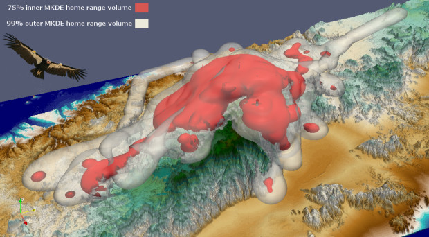
Modern biotelemetry tracking devices, such as those that incorporate GPS level accuracy, collect data on animal locations in three (x,y,z) dimensions – the familiar latitude (x) and longitude (y) of planar geographic coordinates, as well as the z-dimension that measures the vertical component.
This vertical component could be how deep a seal is diving or how high an eagle is flying.
The analytical package used here was developed as a collaboration between San Diego Zoo Global, USGS, and the San Diego Supercomputer Center.
In the image, I used GPS data acquired remotely from a tracking unit attached to a bird’s wing and bounded the home range calculation using a digital elevation model of the Baja terrain (since the bird cannot fly beneath the earth).
The dark red surface contours in the middle of the bird’s home range represent areas that this bird has been using more intensively than the outer transparent white regions. We can then make inferences about its habitat use by matching these 3D home range volumes to aspects of the surrounding environment.
What animal did you track the home range of here?
The condor is also an iconic and charismatic animal and a big conservation success story, so I felt seeing the full extent of a condor’s 3D home range across mountains that the species hasn’t been seen in since it was extirpated in the 1940s would resonate.
I created this 3D home range model using GPS telemetry data collected from a free-ranging California condor that San Diego Zoo Global has recently reintroduced to its former range in the mountains of northern Baja California, Mexico.
The condor is an ideal species to demonstrate this 3D technique because it has a major vertical component to its movements and can fly many hundreds of meters high in the sky as it soars on its huge 2.7 meter wings.
The condor is also an iconic and charismatic animal and a big conservation success story, so I felt seeing the full extent of a condor’s 3D home range across mountains that the species hasn’t been seen in since it was extirpated in the 1940s would resonate.
Back in the 1980s there were just 22 condors in existence. This year there are now around 430 birds, about half of which are flying free again in the wild, and I am grateful to BMC Ecology for this opportunity to showcase condor conservation efforts.
Using a 3D home range model is more informative than a 2D model, why is this?
3D home range models are much more informative and biologically realistic for visualizing and analyzing the space use of animals than traditional 2D models, particularly for species that have a major vertical component to their movements such as birds and marine mammals.
For example, if we used a traditional ‘flat’ 2D model to estimate the home range of a tracked sealion, the model might suggest that the animal occupied only a small area when in fact its 3D home range volume extends deep into the ocean.
3D home range models are also useful from a conservation management perspective. For example, a 3D home range volume would better indicate the risk of a tracked eagle colliding with a field of wind energy turbines that intersect its 3D home range in the vertical dimension than a 2D model would. You could also use 3D home range volumes to gauge the risk posed to tracked marine turtles from getting snagged in gill nets set on the seafloor.
What inspired your interest in investigating the spatial ecology, habitat use and socioecology of animals?
Spatial ecology (the study of how animals and plants interact with their environment through space and time) has become the fastest growing field in ecology because it is being driven by rapid developments in techniques and technologies for collecting spatial data.
Biotelemetry tracking devices are getting smaller and lighter and incorporating new sensors that enable an increasing range of smaller animals to be safely tracked at greater accuracies for longer deployment times.
I have always been drawn to both animal behavior and new gadgets, so spatial ecology was a natural fit for me.
Remote sensing platforms, such as satellites and drones, are enabling high-resolution data to be collected in near real time on the habitats that animals use at the scale of entire landscapes. So, it really is a very exciting time to be a spatial ecologist!
I have always been drawn to both animal behavior and new gadgets, so spatial ecology was a natural fit for me. I also feel that ecologists have a moral imperative to ensure that their research benefits the endangered species they study, and the new technological tools available to us have phenomenal applications to enhance conservation management.
Drones, camera traps and biotelemetry devices are now helping with anti-poaching efforts. Working in species conservation can get depressing with all the bad news that typically accompanies it, so seeing how new spatial technologies are aiding the fight against extinction is really inspiring and encouraging.
What do you hope will be achieved in this field in the future?
New technologies are enabling spatial ecologists to collect bigger, more accurate and more detailed datasets on wild animals and their habitats. However, the methods and models needed to properly analyze, summarize and contextualize these data have not kept pace.
We need concomitant advances in analytical techniques if we are to truly capitalize on this new golden age of ecological Big Data, otherwise we may literally not be able to see the forest for the trees!
I feel that our 3D home range approach is a good step in this direction, and the new methods being introduced that explicitly incorporate the 4th dimension of time into analyses of animal space-use are a very promising avenue of inquiry.

Comments