Hurricane Sandy made landfall in the greater New York City (NYC) area on October 29, 2012. The storm caused 43 deaths and contributed to US$19 billion in damage in NYC alone. Around 63,000 houses were damaged and 300 destroyed. Thousands of residents experienced limited access to safe food or water, healthcare, and public transportation.
The scientific literature reports posttraumatic stress and depression to be among the most common mental health problems after natural disasters like Sandy. Posttraumatic stress and depression are not equally distributed across the population in the aftermath of disasters.
Residents who are socioeconomically disadvantaged, as well who have endured exposure to traumatic and stressful events, such as the loss of a loved one or property damage, are at greater risk of psychological adversity. On the other hand, higher socioeconomic status and social support are protective against mental health problems.
Geographic variation in vulnerability?
There are lingering questions, however, about the geographic distribution of posttraumatic stress and depression. In what neighborhoods, for example, were residents at greater risk for adverse outcomes after Sandy? Did the risk and protective factors vary in different neighborhoods?
Our team aimed to explore such issues by surveying residents of NYC neighborhoods that were most severely affected by Hurricane Sandy. We conducted interviews over landline and cellular telephones with a random sample of residents.
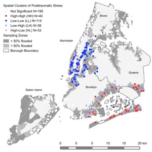
Spatial clusters of posttraumatic stress and depression
Were there areas within NYC with especially high levels of symptoms after Hurricane Sandy? Our analysis suggested that this was indeed the case.
Clusters of more severe posttraumatic stress were identified within neighborhoods of Queens, including Far Rockaway and Breezy Point, and Brooklyn, including Sheepshead Bay and Canarsie. Clusters of severe depression were identified in Queens only, within the Brookville, Far Rockaway, and Arverne neighborhoods.
Other neighborhoods showed low levels of symptoms. Clusters of low posttraumatic stress were identified in Manhattan, such as on the Upper East Side and East Harlem, and Brooklyn, in such neighborhoods as Williamsburg and Brooklyn Heights. Areas of Staten Island – such as Fort Wadsworth and Willowbrook – had clusters of low depression.
Risk and protective factors vary across the NYC boroughs
Our analysis also showed that risk and protective factors are context dependent. Disaster-related stressors, Asian ethnicity and non-Hispanic Black race were predictive of mental health problems in Queens, and being employed and married were found to reduce these problems in Manhattan and Staten Island.
Parenthood was shown to be both a risk and protective factor – contributing to mental health problems in Brooklyn and reducing these problems in the Bronx.
The geography of adversity
Our analytic approach can help us better understand where residents are living at greater risk, and identify risk and protective factors that are specific to a given neighborhood. These will be important goals as we continue to cope with a changing climate and boost community resilience both prior to and in the aftermath of natural disasters.
Comments