What is your profession?
I am an earth scientist (Physical Geographer) working at the University of Amsterdam, Institute for Biodiversity and Ecosystem Dynamics, in the Theoretical Computational Geo-Ecology (TCE) Group. I am responsible for remote sensing and Geographical Information Systems (GIS) courses, but also geological and geomorphological field work, a great combination!
What type of research are you involved in?
I studied Physical Geography at the University of Amsterdam. During my Ph.D. research, I developed methods for the evaluation of natural hazards based on detailed geomorphological mapping. Currently, my research is part of the Theoretical Computational Geo-Ecology group at the University of Amsterdam and is focusing on the functioning of Geo-Ecosystems by analyzing the 3D structure of both the landscape and the vegetation cover using air-born and terrestrial LiDAR-based (Lase Detection and ranging) high resolution elevation data as well as geodiversity mapping at multiple scales.
Currently, my research is part of the Theoretical Computational Geo-Ecology group at the University of Amsterdam and is focusing on the functioning of Geo-Ecosystems by analyzing the 3D structure of both the landscape and the vegetation cover using air-born and terrestrial LiDAR-based (Lase Detection and ranging) high resolution elevation data as well as geodiversity mapping at multiple scales.
Why did you become interested in this area of research?
There is a huge environmental knowledge gap between (landscape) ecological sciences and environmental sciences (geology, geomorphology) at fine scales, and over large extents.
The use of remote sensing data such as LiDAR and very high-resolution air-photos, (collected by airborne platforms or unmanned airborne vehicles – UAVs, drones) can overcome this knowledge gap. For that, intensive cloud computing facilities are necessary (see: https://www.esciencecenter.nl/project/eecolidar, in which I am involved).
How did you become interested in photography?
In my profession, for a long time I relied on the interpretation of satellite imagery and all kinds of aerial photographs (panchromatic, Infrared, multi- and hyperspectral). Synergy of such images and field photo’s generated an immense source of understanding, information, and insight into the functioning of ecosystems. For educational purposes, for research and for just fun it is a visual time capsule because monitoring of landscapes is a prerequisite to learn from the past and be able to make scenarios for the future.
Where and how was this photo taken?
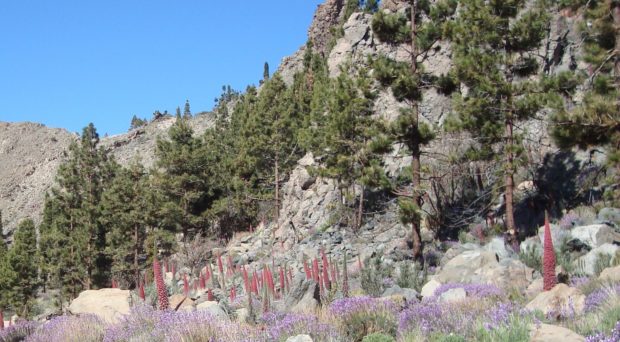
The photo was taken May 5th, 2016 (12.04 hr) at approximately 2075m altitude in ‘Las Cañadas del Teide’ on Tenerife island, Spain. Camera: Sony DSC-W110.
Why were you there at the time?
I combined a short 1 week vacation on Tenerife in May with the preparation for a fieldwork course – Vulnerability Assessment of Geo-ecosystems” – that I coordinate in September / October for students earth Science and Future Planet Ecosystem Science, in order to see the landscape during the flowering season and to have a detailed view on micro-habitats. Each year these students spent two weeks on Tenerife to learn about abiotic and biotic systems.
Can you explain a bit more about the image?
What we see is a micro-habitat on the north-facing caldera slopes at 2100m altitude in ‘Las Cañadas del Teide’ on Tenerife island, Spain. Shown here are a rare mixture of the Canary pine (Pinus canariensis) and the flowering endemic Teide bugloss (Echium wildpretii), amongst other plants, such as the rosallilo de cumbre (Pterocephalus lasiospermus). The unique geological environment and geomorphological development created a specific micro-habitat, perfectly suitable for both the Canary pine trees invading from outside the caldera depression and the Echium wildpretii, a rare species fully adapted to survive in this harsh terrain.
The micro-habitat is formed by coarse rock fall deposits, piling up at the foot of the >3 million years old basaltic cliffs, creating local scree slopes. Locally, fine-grained sub-horizontal soil patches, form behind larger fallen blocks, as the result of fine-scale surface runoff and sediment transport and deposition, which, in combination with mechanical and chemical weathering, release sufficient nutrients from the basaltic parent material to sustain this unique vegetation cover. Signs of a forest fire, especially on the pine trees, emphasize the vulnerability and dynamic nature of this ecologically fragile (micro-)ecosystem.
What about this scene particularly interested you?
The relation between active geomorphological processes, invasion of and competition between plants in a harsh environment is amazing. The patch dynamics within larger ecological zones is striking, the vulnerability, but also the resilience of this fragile ecosystem is exceptional. And of course, it is simply beautiful scenery.
Comments